Explore climate and latitude relative to the settlement of the original 13 …
Explore climate and latitude relative to the settlement of the original 13 colonies.
GeoInquiries are designed to be fast and easy-to-use instructional resources that incorporate advanced web mapping technology. Each 15-minute activity in a collection is intended to be presented by the instructor from a single computer/projector classroom arrangement. No installation, fees, or logins are necessary to use these materials and software.
Students will explore global climatic datasets to analyze the factors that constrain …
Students will explore global climatic datasets to analyze the factors that constrain and enable agricultural options.
GeoInquiries are designed to be fast and easy-to-use instructional resources that incorporate advanced web mapping technology. Each 15-minute activity in a collection is intended to be presented by the instructor from a single computer/projector classroom arrangement. No installation, fees, or logins are necessary to use these materials and software.
Investigate characteristics of major biomes and examine the impact of land-use changes …
Investigate characteristics of major biomes and examine the impact of land-use changes as the result of human activities.
GeoInquiries are designed to be fast and easy-to-use instructional resources that incorporate advanced web mapping technology. Each 15-minute activity in a collection is intended to be presented by the instructor from a single computer/projector classroom arrangement. No installation, fees, or logins are necessary to use these materials and software.
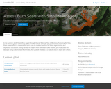
In this project, you'll assume the role of a geospatial scientist working …
In this project, you'll assume the role of a geospatial scientist working with the Montana Forestry Department to analyze the damage in Glacier National Park. You'll first compare Landsat 8 imagery from before and after the fires. Then, you'll change the band combination of the post-fire imagery in order to emphasize burn scars and make a qualitative judgment. Afterward, you'll quantify your assessment by calculating a Normalized Burn Index (a ratio designed to highlight burned areas) from the imagery. Lastly, you'll create a feature class to represent the burn scar, calculate its acreage, and publish it to ArcGIS Online to share with the department.
Explore the ideas and evidence that helped Charles Darwin create his theory …
Explore the ideas and evidence that helped Charles Darwin create his theory of evolution.
GeoInquiries are designed to be fast and easy-to-use instructional resources that incorporate advanced web mapping technology. Each 15-minute activity in a collection is intended to be presented by the instructor from a single computer/projector classroom arrangement. No installation, fees, or logins are necessary to use these materials and software.
Find areas that are predicted to change because of climate change. GeoInquiries …
Find areas that are predicted to change because of climate change.
GeoInquiries are designed to be fast and easy-to-use instructional resources that incorporate advanced web mapping technology. Each 15-minute activity in a collection is intended to be presented by the instructor from a single computer/projector classroom arrangement. No installation, fees, or logins are necessary to use these materials and software.
Explore factors that define levels of development. GeoInquiries are designed to be …
Explore factors that define levels of development.
GeoInquiries are designed to be fast and easy-to-use instructional resources that incorporate advanced web mapping technology. Each 15-minute activity in a collection is intended to be presented by the instructor from a single computer/projector classroom arrangement. No installation, fees, or logins are necessary to use these materials and software.
As GIS technicians, students examine dams along the Mersey River Watershed to …
As GIS technicians, students examine dams along the Mersey River Watershed to determine whether there are any locations suitable for the construction of a fishway. Once they identify the best potential location, they will calculate the dam's upstream watershed to help determine how much additional habitat could be made accessible by constructing the fishway.
In this activity, students investigate dynamics in the earth's crust that explain …
In this activity, students investigate dynamics in the earth's crust that explain multiple Earth Science phenomena.
GeoInquiries are designed to be fast and easy-to-use instructional resources that incorporate advanced web mapping technology. Each 15-minute activity in a collection is intended to be presented by the instructor from a single computer/projector classroom arrangement. No installation, fees, or logins are necessary to use these materials and software.
Since the collapse of the Soviet Union in 1991, the Ukraine has …
Since the collapse of the Soviet Union in 1991, the Ukraine has been an independent democratic nation. Given its location between Europe and Russia, it often must balance the political tensions between Russia and the West. This tension came to a peak in late 2013, when the president of the Ukraine chose not to sign an economic agreement with the European Union and instead pursued closer ties to Russia. This upset many people living in Ukraine who took to the streets in extended protests resulting in the eventual removal of the Ukrainian president and several other high-level officials of the government. Shortly thereafter, a new pro-Europe leadership was installed by parliament. Amidst all this uncertainty and political change in Ukraine, Russian soldiers invaded Ukraine's Crimean Peninsula in March of 2014, taking control of airports, naval bases, and key bridges. Within weeks, Russia claimed Crimea as their own. Successful students will be able to ask questions to define how the cultural and ethnic diversity of this area might contribute to the current conflict.
This activity shows how the expansion of the Japanese Empire resulted in …
This activity shows how the expansion of the Japanese Empire resulted in the United States' involvement in World War II.
GeoInquiries are designed to be fast and easy-to-use instructional resources that incorporate advanced web mapping technology. Each 15-minute activity in a collection is intended to be presented by the instructor from a single computer/projector classroom arrangement. No installation, fees, or logins are necessary to use these materials and software.
Explore water pollution and its impact on ocean life in aquatic dead …
Explore water pollution and its impact on ocean life in aquatic dead zones.
GeoInquiries are designed to be fast and easy-to-use instructional resources that incorporate advanced web mapping technology. Each 15-minute activity in a collection is intended to be presented by the instructor from a single computer/projector classroom arrangement. No installation, fees, or logins are necessary to use these materials and software.
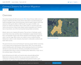
In this project, you'll build a web mapping application that identifies which …
In this project, you'll build a web mapping application that identifies which region of Samut Songkhram province should be the focus of conservation efforts. You'll retrieve one image for each decade since the 1970s from the Living Atlas Landsat archive for the entire study area. Once you have the images, you will alter the available multispectral data to enhance vegetation, land, and water. Then, you will configure the time animation tool in ArcGIS Online, and create a custom time-aware application for publishing your observations.
Students will explore how not all distances are equally distant. GeoInquiries are …
Students will explore how not all distances are equally distant.
GeoInquiries are designed to be fast and easy-to-use instructional resources that incorporate advanced web mapping technology. Each 15-minute activity in a collection is intended to be presented by the instructor from a single computer/projector classroom arrangement. No installation, fees, or logins are necessary to use these materials and software.
Explore the impact of human activities on water resources. GeoInquiries are designed …
Explore the impact of human activities on water resources.
GeoInquiries are designed to be fast and easy-to-use instructional resources that incorporate advanced web mapping technology. Each 15-minute activity in a collection is intended to be presented by the instructor from a single computer/projector classroom arrangement. No installation, fees, or logins are necessary to use these materials and software.
Explore the Dust Bowl region using population change, agriculture, and precipitation data. …
Explore the Dust Bowl region using population change, agriculture, and precipitation data.
GeoInquiries are designed to be fast and easy-to-use instructional resources that incorporate advanced web mapping technology. Each 15-minute activity in a collection is intended to be presented by the instructor from a single computer/projector classroom arrangement. No installation, fees, or logins are necessary to use these materials and software.
This activity explores patterns and characteristics of El Niño and effects on …
This activity explores patterns and characteristics of El Niño and effects on global climate.
GeoInquiries are designed to be fast and easy-to-use instructional resources that incorporate advanced web mapping technology. Each 15-minute activity in a collection is intended to be presented by the instructor from a single computer/projector classroom arrangement. No installation, fees, or logins are necessary to use these materials and software.
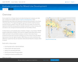
In this project, students evaluate areas in Gresham, Oregon, a city of …
In this project, students evaluate areas in Gresham, Oregon, a city of about 100,000 people located east of Portland. They look for suitably-zoned areas where young adults are known to live and where renting is common. Since many of the prospective tenants will commute to Portland, students also look for areas that afford easy access to the city's light-rail system. While these are not the only factors that determine a good site, they are important criteria that will help the company refine its search.
This lesson focuses on the use of elevation maps with a focus …
This lesson focuses on the use of elevation maps with a focus on Michigan's Muskegon River Watershed. Students are introduced to an elevation profile tool and expected to produce a profile of two other Michigan rivers and examine their watersheds. Success with this lesson will include drawing a simplified profile of one of the rivers as well as labeling two watershed boundaries and the river.
No restrictions on your remixing, redistributing, or making derivative works. Give credit to the author, as required.
Your remixing, redistributing, or making derivatives works comes with some restrictions, including how it is shared.
Your redistributing comes with some restrictions. Do not remix or make derivative works.
Most restrictive license type. Prohibits most uses, sharing, and any changes.
Copyrighted materials, available under Fair Use and the TEACH Act for US-based educators, or other custom arrangements. Go to the resource provider to see their individual restrictions.